| Location | Zacatecas, Mexico |
| Ownership | 100% |
| Land Position | 6500 ha |
| Status | Advancing through permitting |
| Metals | Gold |
| Mineral Resources | PEA Published in 2022 |
| Mining Processing and Concept | Open pit mining with heap leach processing |
Highlights
- Extensive past drill campaigns identifying a broad disseminated gold system
- Metallurgical testwork indicates the gold is amenable to conventional heap-leach extraction
- Excellent infrastructure
- Significant exploration upside
PEA Highlights
Average Annual Production - 58,400 oz gold
Pre-Production Capital - US$28 million (including 30% contingency)
Sustaining Capital - US$14.7 million
LOM Average AISC - US$873/oz
Mine life - 8.2 years
Mining Rate - 20,000 tpd
LOM Grade and Recovery - 0.37 g/t Au (68% recovery)
LOM Strip Ratio - 0.3:1 (waste to mineral)
Gold price used - US$1,600/oz
FX Rate used (MXP/US$) - 20
Overview
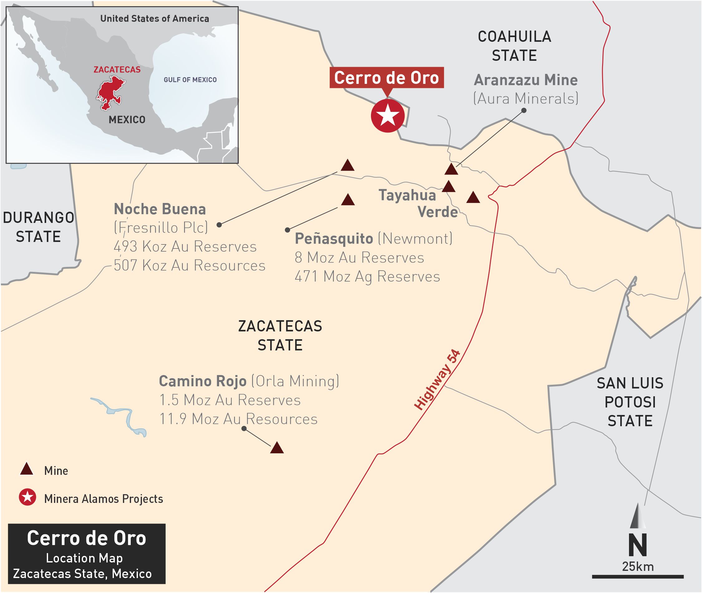
The ~6,500-hectare Cerro de Oro gold project is located in northern Zacatecas State, Mexico and is accessible by paved highway. It is strategically positioned within the Concepcion del Oro mining district that includes several gold and polymetallic mines and deposits including Newmont’s Peñasquito gold/silver mine and Fresnillo’s Noche Buena gold mine.
Historic mining in the district focused on higher-grade skarn-replacement type mineralization. More recent drilling has identified broad zones of intrusive-hosted gold mineralization. The Cerro de Oro property and surrounding claims present an open-pittable target of disseminated gold mineralization where previous metallurgical testwork has indicated it should be amenable to conventional open-pit/heap leach processing and extraction.
Historical Background
The property contains numerous historical pits, trenches and U/G workings. Although some of the site activity appears to be from earlier periods, the most significant period of recorded activity occurred in the 1950s and described a series of exploration pits, shafts, declines and adits around the side of the Cerro de Oro hill in the center of the concession area. Two areas of high-grade underground structures were mined via adits and declines from surface with a series of internal raises and cross-cuts down to a vertical depth of approximately 150 meters.
Between 1993 and 1998, Noranda completed 34 reverse circulation (RC) holes to depths of 60-100 metres and seven diamond drill holes to 400 metres on and adjacent to the concessions. Results confirmed widespread variable gold mineralization. More recently, a private entity completed approximately 50 RC holes confirming the earlier work by Noranda and presenting an excellent disseminated mineralized system which remains open in multiple directions.
Geology & Mineralization
In the Concepcion del Oro region, Cretaceous-age sedimentary rocks are folded into a set of anticlines and synclines. The stratigraphy, consisting mostly of calcareous shale interbedded with limestone and sandstone of the Caracol formation, is steeply dipping. There are also significant amounts of thicker bedded limestone in the area. The Cerro de Oro mineralized zone is located midway between a large syncline that passes a through the town of Melchor Ocampo and a paired anticline about three kilometers to the north.
A granodiorite porphyry intrudes the earlier sedimentary rocks and outcrops in the central parts of the mineralized zone. The outcropping granodiorite contains mineralization ranging from quartz veinlet type to fracture type stockwork.
Deposit Types
There are two types of deposits in the Concepcion de Oro region: skarn-replacement and porphyry style. Historic mining focused on higher-grade skarn-replacement mineralization including mantos and and chimney form breccias. These deposits are closely related to and contained within an intrusive typical of classic “porphyry style” gold mineralization.
More recent exploration has confirmed broad zones of porphyry style mineralization including gold-bearing disseminations and quartz and fracture stockwork related to a granodiorite stock.
Current Exploration
Plans for additional drilling and metallurgical testwork for future operation planning are being formulated and announced in due course.
Technical Report
NI 43-101 maiden resource statement has been published and it is available on SEDAR.